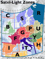
The maps used on the server are based on a commercial product called Mountain High Maps (MHM) from Digital Wisdom Incorporated. This product has been selected because it provides a set of very good looking maps. However, this is not a Geographic Information System (GIS). Therefore, the original MHM maps have been checked and modified when necessary, to make all their features (country borders, cities, rivers…) strictly respect their projection. An inverse projection is used to establish the correspondence between any point on the map and a pixel of the satellite image. For more information on map projections, see the book: Map Projections, A Reference Manual, by Bugayevskiy L.M. and Snyder J.P. (Taylor and Francis publishers, 1995). The Satel-Light server produces maps for all Europe (called zone Z) or for any of 13 zones in Europe. The table below presents each of these maps, its size using the GIF format, the type of projection used to generate it and the countries covered entirely by the map. A click on the icons provides a full size GIF version of each map. A map is 500 pixel wide and fits on an A4 page. An area not covered by the satellite image is shown in grey and outlined by a blue border. The location and the name of the cities displayed on the maps correspond exactly to those available in our city name database.
|
)
)
)
)
)
)
)
)
)
)
)
)
)
)