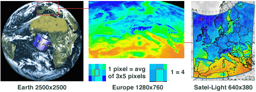
The satellite data Since 1977, six Meteosat satellites have been launched and operated by the EUMETSAT organisation. A Meteosat type satellite is a geostationary satellite located on the equatorial plane, at a longitude of 0 degree, and at an altitude close to 36,000 km. It sees one half of the earth and measures the reflected radiation in three spectral bands: visible (between 0.5 and 0.9 µm), water vapour (between 5.7 and 7.1 µm) and infra red (between 10.5 and 12.5 µm). The raw images provided by Meteosat have a maximum resolution of 5,000 pixels by 5,000 pixels in the visible, and 2,500 pixels by 2,500 pixels in the other channels. It takes 25 minutes for Meteosat to get all pixel values from the south pole to the north pole, an image is produced every 30 minutes. This implies that there is a difference between the time at which the image is produced by the satellite, and the time at which the radiation reflected by one pixel of the earth, is measured by the satellite. If the image is produced at 10:00 GMT, a pixel overlooking Gibraltar is seen at 9:50 GMT, while a pixel overlooking Sankt Peterburg is seen at 9:54 GMT. The Satel-Light data is based on the Meteosat images produced in the visible channel at the resolution of 2,500 pixels by 2,500 pixels. The processing of the satellite image is summarized in the figure below. Only the pixels covering Western and Central Europe: 1280 pixels in longitude and 760 pixels in latitude are processed. Then, each pixel is averaged over a "square" of 3 pixels in latitude by 5 pixels in longitude. Various tests have showed that the best agreement between ground data and satellite data is obtained, not when using one pixel, but when using multiple pixels. This compensates for the unstable situations for which the available irradiation has large variations during the half hour period. Then, the resolution of the image is reduced again by taking one over two pixels in latitude and longitude for a total of 640 pixels in longitude by 380 pixels in latitude.
Once the pixels covering the outer space have been removed, this leads to the effective use of 241,913 pixels to cover Western and Central Europe. One pixel covers an area which ranges from about 5 km in longitude by 6 km in latitude, at a latitude of 34°N (North Africa), to about 5 km in longitude by 16 km in latitude, at a latitude of 64°N (Scandinavia). The estimation of cloud cover In Satel-Light, the only parameter directly computed from the satellite image is the global horizontal irradiance.All other parameters are computed from it. The global horizontal irradiance is estimated from the pixel value of the satellite image using the concept of the Heliosat method, proposed by Cano et al. in 1986 (Cano, 1986). This method was modified by Beyer et al., in 1996 (Beyer, 1996) and further improvements have been made to it for Satel-Light. The Heliosat method is based on the assumption that the albedo of a cloudy atmosphere will usually be larger than the albedo of the ocean or the earth surface (this is not true if the ground is covered with snow). Thus, the increase of the albedo gives a measure of the cloud cover. The pixel value (also called a count) depends on the energy radiated by the sun at the time the satellite sees the pixel. For a correct estimation of the change in the albedo, this influence has to be taken into account. Therefore, the pixel value C (an integer from 0 to 255) is normalized with respect to the sun altitude, to obtain
Co is called the registration offset. Its computation has been fully described (Hammer, 1998). It is the sum of the satellite instrument offset (a value of 5) and the contribution of the backscattering of solar radiation in the atmosphere. Eesno is the extraterrestrial normal irradiance and Then, the albedo is used to compute the cloud index
The cloud index provides a measure of cloud cover. The presence of snow increases significantly the albedo, making the detection of cloudless situations almost impossible when using only the satellite visible channel. Unfortunately, the current generation of Meteosat satellites do not offer channels which could be used to make the distinction between snow cover and cloud cover. This means that a pixel overlooking an area covered with snow during part of the month is considered as a pixel overlooking an area covered with clouds during that same period of time. The solar radiation for this pixel will then be underestimated. For solar elevations below 6°, the satellite radiometer cannot really make the difference between a pixel with clouds or without clouds. When this happens, the cloud index value at that time is not used, it is replaced by the closest cloud index corresponding to a solar elevation above 6°. If none is available during that day (this may happen during the winter at high latitudes) then a constant value of 0.50 is used throughout the day. |